


-83%

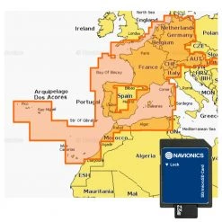
Navionics Platinum Chart Card Nova Scotia To St. Lawrence River SD/MSD Card
Original price was: £561.00.£96.99Current price is: £96.99.
- Protect Your Wallet with Safe Payments
- 100% High Quality Guarantee
- Buy with confidence, backed by quality.
- We take quality seriously.


Bring the ocean floor to life!
The award winning Navionics Platinum Chart Card
comes packed with the best cruising features available for your
chartplotter! Boasting its excellent cartography and an extensive
photo library, this multi-dimensional marine chart offers
navigators and fishermen a wide selection of bonus information that
goes well beyond the available navigation charts today. It features
panoramic pictures, 3D/2D views with satellite imagery, coast pilot
guide, POI and a built-in offshore fishing detail. Navionics uses
the largest scale charts available to provide accuracy and the best
details of a given area.
Navionics Platinum Chart Card Features:
- Chard card for Nova Scotia – St. Lawrence River
- Seamless chart details
- View depths and elevations in 3D
- Photo overlay allows comparison with chart information thus
improving situation awareness - Improve your approach with over 15,000 photos of harbours and
marinas - Detailed information; including phone numbers for port services
and points of interest - Geo-referenced coast pilot automatically displays the paragraph
pertaining to a selected marina - SD/MSD Card
Be the first to review “Navionics Platinum Chart Card Nova Scotia To St. Lawrence River SD/MSD Card”
Related products
-64%
Original price was: £269.00.£97.99Current price is: £97.99.
-78%

Original price was: £419.00.£93.99Current price is: £93.99.
-64%
Original price was: £269.00.£95.99Current price is: £95.99.
-65%
Original price was: £269.00.£92.99Current price is: £92.99.
-84%
Original price was: £599.00.£97.99Current price is: £97.99.
-78%
Original price was: £419.00.£92.99Current price is: £92.99.
-78%
Original price was: £419.00.£93.99Current price is: £93.99.
-64%
Original price was: £269.00.£97.99Current price is: £97.99.
Reviews
There are no reviews yet.