


Navionics Plus 31XG Chart Card Indian Ocean To South China Sea CF Card
Original price was: £359.00.£92.99Current price is: £92.99.
- Protect Your Wallet with Safe Payments
- 100% High Quality Guarantee
- Buy with confidence, backed by quality.
- We take quality seriously.


Whether you are on the water or planning a trip, Navionics Gold
charts can take you there!
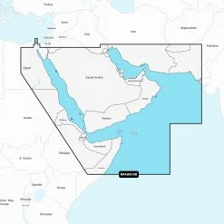
The Navionics Plus 31XG Indian Ocean to South China Sea CF
Card is a compact flash card with a 2-dimensional marine
chart that is considered to be the navigation standard for serious
mariners and fishermen. It features a paper chart appearance with
user friendly features and offers the largest coverage areas for
the widest range of today’s most popular chartplotters. It provides
superior detail, shaded depth contours, real-world shapes, colors
for buoys and navaids, tide and current data, spot soundings and
many more. Just plug and play into a Navionics
compatible plotter and have easy access to all the essential
information found on official paper charts and fishing maps. These
Navionics charts provide navigators and fishermen
all the necessary data for safer and easier navigation.
Coverage
The Navionics Gold Indian Ocean to South China Sea
covers areas such as: Pakistan, India, Sri Lanka, Bangladesh,
Burma, Thailand, Malaysia, Singapore, Cambodia, Vietnam, Maldives,
Solomon Islands, Diego Garcia, Philippines, Brunei, Indonesia.
Including Selat Sunda, Strait of Malacca, Gulf of Thailand, Andaman
and Nicobar Islands, Bay of Bengal and Arabian Sea.
Compatible Models For: Navionics Plus CF Chart
Card:
- Raymarine: G-Series G120, G150, G170, G190,
GPM400; E-Series Widescreen E140W, E120W, E90W; C-Series Widescreen
C140W, C120W, C90W; A-Series 70, 70D, 57, 57D, 50, 50D - geonav: 11 C Net; 11 C; 7 Wide, Wide Net; 5
Touring; 4 Gipsy, Gipsy NMEA; Multy; 11 Flash, Sun, Sunshine; 10 C;
8 Sunshine; 7 C; 6 Sun, Sunshine; 5 C; 4 CXS, C - Northstar: 6100i (requires S/W update 7.76);
6000i
What happens if your Model of GPS is not on the list
above? Most likely this is the wrong chart for your
machine! So try looking through our range of other GPS
Charts to find the correct card for your unit. Or you can also
check the Navionics website for the latest
Compatibility Guides
Be the first to review “Navionics Plus 31XG Chart Card Indian Ocean To South China Sea CF Card”
Related products

Reviews
There are no reviews yet.